| Super Old pic of Portman Road on 21:58 - Jan 28 with 1105 views | WubbleU |
| Super Old pic of Portman Road on 21:38 - Jan 28 by Illinoisblue |
Curious why you would think it was AI generated? |
Just suspicious of the cricket boundary, I thought the cricket club left much earlier. It is clearly all good though.
In fact suspicious of everything I see!  |  | |  |
| Super Old pic of Portman Road on 22:00 - Jan 28 with 1092 views | jasondozzell |
| Super Old pic of Portman Road on 21:42 - Jan 28 by DJR |
Fascinating also to see all the long disappeared houses. And at the top middle in white, I think you can make out the Black Horse, with the church (St. Peter's?) near to it.
Here's a link to a 1927 map which you can zoom in on to see the ground and stand.
https://maps.nls.uk/view/11450 [Post edited 28 Jan 21:52]
|
St Mary's at the Elms? |  | | |
| Super Old pic of Portman Road on 22:16 - Jan 28 with 1047 views | backwaywhen |
| Super Old pic of Portman Road on 21:50 - Jan 28 by DJR |
It only closed in 1985, and here's an article about it. I certainly remember it as a cattle market.
https://www.eadt.co.uk/news/21 |
We as kids lived in Curriers Lane and spent many a happy time on the old cattle market , help the drivers wash down the cattle trucks with the water jets they had over there , go inside the auction rings and watch the bidding , finish off wandering to Alderman Rd park for a kick about ……Happy days back in the 60s. | | | |
| Super Old pic of Portman Road on 22:17 - Jan 28 with 1051 views | Churchman |
The Chicken Run was built in about 1907. It is built on old waste ground, which you see the imprint of (the ground is darker). The Chicken Run was just that. When it wasn’t being used, the area under the stand was rented out to run chickens.
Behind the stand was trees, which are actually present in the photo in the attached (I make no apologies for posting this again) were blown down in a storm and removed before WW1.
https://ueaeprints.uea.ac.uk/i
The pitch originally ran left to right more or less where Churchmans and the car park is now. Yes, that is the Churchmans cigarette factory. A number of the players went to work there during the war. My father actually played field hockey for them just after the war, strangely enough, before National Service kicked in..
Talking of that, the ground was turned over to the War Office in WW1 and it took two years after wars end to get the ground in a fit state to play. Ipswich Town were the only English club not to play match in either world war. Very much the ‘spirit of the amateur’ and duty before pleasure and all that.
Another odd fact - player’ kit was washed by somebody in Alderman Road (the road behind North Stand) back in the day.
Ipswich were one of the early adopters of goal nets in 1890 and the first game Ipswich played under lights was 17 December 1878 at the original Brooks Hall ground. A one off exhibition, the lights powered by two Ransomes engines.
Lastly, Everton were formed the same year as Ipswich Town, though their history took very different paths. [Post edited 28 Jan 22:24]
|  | | |
| Super Old pic of Portman Road on 22:28 - Jan 28 with 1027 views | WestStanderLaLaLa |
| Super Old pic of Portman Road on 21:42 - Jan 28 by DJR |
Fascinating also to see all the long disappeared houses. And at the top middle in white, I think you can make out the Black Horse, with the church (St. Peter's?) near to it.
Here's a link to a 1927 map which you can zoom in on to see the ground and stand.
https://maps.nls.uk/view/11450 [Post edited 28 Jan 21:52]
|
The houses struck me too, wondering if the ones off Princes Street went after a flood event, I found this which has a view of Portman Road and a Pathe news reel
https://www.greatbritishlife.c |  |
| |
| Super Old pic of Portman Road on 22:41 - Jan 28 with 996 views | Freddies_Ears |
Note that the West terrace was still temporary up to then ( up to at least 1936), so it was removed for cricket each summer. The cricket pitch shown was for reserve fixtures; the main wicket was in the Fanzone area. | | | |
| Super Old pic of Portman Road on 00:41 - Jan 29 with 947 views | AbujaBlue |
Thanks for sharing this. I was randomly looking at the history of Portman Road on Wiki earlier today when I was supposed to be working and I was wondering what the cricket ground would have looked like. Fantastic timing!
On a slight sidenote, I visited the Genoa football museum last year and they had a fantastic set of models showing the development of their football ground(s) up to the current Luigi Ferraris stadium - including when it was a cricket ground. Wouldn't it be amazing if someone did the same for the different iterations of Portman Road? |  | | |
| Super Old pic of Portman Road on 08:14 - Jan 29 with 860 views | BloomBlue |
| Super Old pic of Portman Road on 22:17 - Jan 28 by Churchman |
The Chicken Run was built in about 1907. It is built on old waste ground, which you see the imprint of (the ground is darker). The Chicken Run was just that. When it wasn’t being used, the area under the stand was rented out to run chickens.
Behind the stand was trees, which are actually present in the photo in the attached (I make no apologies for posting this again) were blown down in a storm and removed before WW1.
https://ueaeprints.uea.ac.uk/i
The pitch originally ran left to right more or less where Churchmans and the car park is now. Yes, that is the Churchmans cigarette factory. A number of the players went to work there during the war. My father actually played field hockey for them just after the war, strangely enough, before National Service kicked in..
Talking of that, the ground was turned over to the War Office in WW1 and it took two years after wars end to get the ground in a fit state to play. Ipswich Town were the only English club not to play match in either world war. Very much the ‘spirit of the amateur’ and duty before pleasure and all that.
Another odd fact - player’ kit was washed by somebody in Alderman Road (the road behind North Stand) back in the day.
Ipswich were one of the early adopters of goal nets in 1890 and the first game Ipswich played under lights was 17 December 1878 at the original Brooks Hall ground. A one off exhibition, the lights powered by two Ransomes engines.
Lastly, Everton were formed the same year as Ipswich Town, though their history took very different paths. [Post edited 28 Jan 22:24]
|
The whole site was originally a tip. Waste was brought in via the railways and dumped there.
Alan Ferguson the groundsman for many years always felt that was why the ground drained naturally. Well it did until they built the Pioneer stand and that caused problems with that, including restricting the natural sunlight into half the pitch. |  | | |
Login to get fewer ads
| Super Old pic of Portman Road on 08:27 - Jan 29 with 845 views | DJR |
| Super Old pic of Portman Road on 22:00 - Jan 28 by jasondozzell |
St Mary's at the Elms? |
You're right.
Incidentally, a couple of years ago I got to Ipswich much earlier than normal, so decided to visit a few of its medieval churches, one of which was St Mary's.
And what Pevsner, the architectural historian, said about churches in Ipswich is interesting.
Pevsner notes of Ipswich that: "Ipswich was an important port in the Middle Ages. Already in Domesday it had nine churches." and "More medieval parish churches are preserved in Ipswich than in any other English town of its size." [Post edited 29 Jan 8:28]
|  | | |
| Super Old pic of Portman Road on 08:29 - Jan 29 with 840 views | Dubtractor |
| Super Old pic of Portman Road on 22:28 - Jan 28 by WestStanderLaLaLa |
The houses struck me too, wondering if the ones off Princes Street went after a flood event, I found this which has a view of Portman Road and a Pathe news reel
https://www.greatbritishlife.c |
Barely any of the buildings to the right of Princes street on that pic still exist. Quite a remarkable amount of change really. |  |
| |
| Super Old pic of Portman Road on 09:27 - Jan 29 with 790 views | mellowblue |
| Super Old pic of Portman Road on 08:14 - Jan 29 by BloomBlue |
The whole site was originally a tip. Waste was brought in via the railways and dumped there.
Alan Ferguson the groundsman for many years always felt that was why the ground drained naturally. Well it did until they built the Pioneer stand and that caused problems with that, including restricting the natural sunlight into half the pitch. |
I remember there being issues with the height of the Sir Alf Stand being South pf the pitch, but not the West Stand. It does not cause any shadows apart from when the sun is very low. | | | |
| Super Old pic of Portman Road on 09:44 - Jan 29 with 776 views | Steve_M |
| Super Old pic of Portman Road on 21:47 - Jan 28 by Dubtractor |
It gets tricky to ID buildings near to the top of the picture without civic drive there to help position things. |
The bit of Princes St the other side of Civic Derive and the junction with Museum Street is the biggest help there I think. | 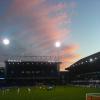 |
| |
| Super Old pic of Portman Road on 09:59 - Jan 29 with 755 views | flykickingbybgunn |
| Super Old pic of Portman Road on 21:04 - Jan 28 by Illinoisblue |
That was an intersting location for a cattle market. Did rum ol’ boys from the farms of Suffolk drive into the metropolis of Ipswich with an empty truck and drive home with new cows? Is that how it worked? |
Ipswich market was on a Tuesday so it is no coincidence that our midweek matches were mostly on that day, as they still often are. The Budgies market was on a Wednesday so they tended to play then.
If you walk from PR towards the station. Just before the bridge take the track off to the right and go to the bend of the river. There you will see the rail bridge that fed the market and the docks. There are still some of the old cattle pens there. | 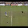 | | |
| Super Old pic of Portman Road on 10:31 - Jan 29 with 732 views | Churchman |
Attached is a map of Ipswich from 1867.
https://maps.nls.uk/view/24595
The cattle market is there. The street patterns are the same, more or less. Noticeably Portman Road is Portmans Road.
The area where the council buildings are off Russell Road were being used but basically west of the cattle market there is nothing much. The area now occupied by the football ground is identifiable. | | | |
| Super Old pic of Portman Road on 10:38 - Jan 29 with 698 views | witchdoctor |
| Super Old pic of Portman Road on 21:08 - Jan 28 by Swansea_Blue |
Oh! So that’s where the name comes from. I’ve not known that in nearly 50 years of going to PR  |
when I first started ‘going’ the factory was there and workers used to stand at the top of the churchman’s building to watch the game.. |  | | |
| Super Old pic of Portman Road on 10:50 - Jan 29 with 682 views | mellowblue |
| Super Old pic of Portman Road on 10:31 - Jan 29 by Churchman |
Attached is a map of Ipswich from 1867.
https://maps.nls.uk/view/24595
The cattle market is there. The street patterns are the same, more or less. Noticeably Portman Road is Portmans Road.
The area where the council buildings are off Russell Road were being used but basically west of the cattle market there is nothing much. The area now occupied by the football ground is identifiable. |
Cartography was a beautiful thing in those days. I assume the railway might have been single track in those days as there seems to be only the single railway platform. Also there must have been an immense land drainage system and filling in of some of the River Gipping's tributaries sometime in the late Victorian era. Must have looked so different and probably not improved visually. | | | |
| Super Old pic of Portman Road on 10:54 - Jan 29 with 675 views | Maccaisgod |
Where was the media lounge? | | | |
| Super Old pic of Portman Road on 10:56 - Jan 29 with 678 views | NthQldITFC |
Fascinating.
Let's do a list of what building are still there. I reckon 95% plus have gone.
Looking at it from a similar viewpoint in 3d G**gle Earth...
https://earth.google.com/web/@ (better angle)
... I reckon these are still there:
Ashtons - legal building corner Portman Road
Canham Street - curved row of houses top left, both sides of road
Little Gipping Street - houses just east of Canham Street
- (houses further east are under Civic Drive now)
Great Gipping Street - houses to the south part of the above
Portman Road - houses at north end making up a quadrant with the above
Atwells - Princes Street
36-42 Museum Street - not easily identifiable, but must be there
St Mary at the Elms church
25 Elm Street
Elm House - Elm Street (was Prettys)
White Horse pub
What else?
(it's not the Curve bar, thanks mellowblue) [Post edited 2 Feb 10:53]
|  |
| |
| Super Old pic of Portman Road on 11:05 - Jan 29 with 656 views | NthQldITFC |
| Super Old pic of Portman Road on 21:42 - Jan 28 by DJR |
Fascinating also to see all the long disappeared houses. And at the top middle in white, I think you can make out the Black Horse, with the church (St. Peter's?) near to it.
Here's a link to a 1927 map which you can zoom in on to see the ground and stand.
https://maps.nls.uk/view/11450 [Post edited 28 Jan 21:52]
|
I think I can make out the church (does it look like it's got a white 'flag' on top?) but I can't see the Black Horse (which must have been there) relative to that?
edit: was way out with this, thanks mellowblue [Post edited 29 Jan 12:05]
| |
| |
| Super Old pic of Portman Road on 11:27 - Jan 29 with 630 views | Vic |
| Super Old pic of Portman Road on 21:42 - Jan 28 by DJR |
Fascinating also to see all the long disappeared houses. And at the top middle in white, I think you can make out the Black Horse, with the church (St. Peter's?) near to it.
Here's a link to a 1927 map which you can zoom in on to see the ground and stand.
https://maps.nls.uk/view/11450 [Post edited 28 Jan 21:52]
|
That's brilliant - so much has changed it's almost unrecognisable.
Loads of questions from looking at that - but one struck me more than it should! 'Tower Ramparts' - whats that about? What were the 'ramparts'? whats the history to this? I assume it's something to do with St Mary le Tower, but I'd never thought about it before.
Factors, can you remember? |  |
| |
| Super Old pic of Portman Road on 11:27 - Jan 29 with 630 views | mellowblue |
| Super Old pic of Portman Road on 10:56 - Jan 29 by NthQldITFC |
Fascinating.
Let's do a list of what building are still there. I reckon 95% plus have gone.
Looking at it from a similar viewpoint in 3d G**gle Earth...
https://earth.google.com/web/@ (better angle)
... I reckon these are still there:
Ashtons - legal building corner Portman Road
Canham Street - curved row of houses top left, both sides of road
Little Gipping Street - houses just east of Canham Street
- (houses further east are under Civic Drive now)
Great Gipping Street - houses to the south part of the above
Portman Road - houses at north end making up a quadrant with the above
Atwells - Princes Street
36-42 Museum Street - not easily identifiable, but must be there
St Mary at the Elms church
25 Elm Street
Elm House - Elm Street (was Prettys)
White Horse pub
What else?
(it's not the Curve bar, thanks mellowblue) [Post edited 2 Feb 10:53]
|
Curve Bar is a smaller 2 storey structure, the architecture is probably from the 30's to 50's, whereas the other curved building was a three storey one from Victorian era or before. It was actually in the middle of what is now Civic Drive. So you were correct to have doubts about it. | | | |
| Super Old pic of Portman Road on 11:31 - Jan 29 with 621 views | Vic |
| Super Old pic of Portman Road on 22:17 - Jan 28 by Churchman |
The Chicken Run was built in about 1907. It is built on old waste ground, which you see the imprint of (the ground is darker). The Chicken Run was just that. When it wasn’t being used, the area under the stand was rented out to run chickens.
Behind the stand was trees, which are actually present in the photo in the attached (I make no apologies for posting this again) were blown down in a storm and removed before WW1.
https://ueaeprints.uea.ac.uk/i
The pitch originally ran left to right more or less where Churchmans and the car park is now. Yes, that is the Churchmans cigarette factory. A number of the players went to work there during the war. My father actually played field hockey for them just after the war, strangely enough, before National Service kicked in..
Talking of that, the ground was turned over to the War Office in WW1 and it took two years after wars end to get the ground in a fit state to play. Ipswich Town were the only English club not to play match in either world war. Very much the ‘spirit of the amateur’ and duty before pleasure and all that.
Another odd fact - player’ kit was washed by somebody in Alderman Road (the road behind North Stand) back in the day.
Ipswich were one of the early adopters of goal nets in 1890 and the first game Ipswich played under lights was 17 December 1878 at the original Brooks Hall ground. A one off exhibition, the lights powered by two Ransomes engines.
Lastly, Everton were formed the same year as Ipswich Town, though their history took very different paths. [Post edited 28 Jan 22:24]
|
So Churchmans was named after your dad then really! | |
| |
| Super Old pic of Portman Road on 11:58 - Jan 29 with 602 views | NthQldITFC |
| Super Old pic of Portman Road on 11:27 - Jan 29 by mellowblue |
Curve Bar is a smaller 2 storey structure, the architecture is probably from the 30's to 50's, whereas the other curved building was a three storey one from Victorian era or before. It was actually in the middle of what is now Civic Drive. So you were correct to have doubts about it. |
Ah yes. That puts the aforementioned church right at top of the picture with the tower cut off and the long red brick building 25 Elm Street just opposite to the right at an angle. | |
| |
| Super Old pic of Portman Road on 12:15 - Jan 29 with 569 views | mellowblue |
| Super Old pic of Portman Road on 11:58 - Jan 29 by DJR |
Churchman's only closed in 1992.
Here's an article about it. And sad to see the old premises where Churchman's originated demolished to make way for more modern buildings.
https://www.ipswichstar.co.uk/ [Post edited 29 Jan 12:00]
|
I think one of the later brands there were John Players ? | | | |
| |
