| Super Old pic of Portman Road on 12:25 - Jan 29 with 1209 views | Dubtractor |
| Super Old pic of Portman Road on 12:15 - Jan 29 by mellowblue |
I think one of the later brands there were John Players ? |
Assume that would explain the old John Player sports ground in Ipswich? |  |
|  |
| Super Old pic of Portman Road on 12:49 - Jan 29 with 1169 views | NthQldITFC |
| Super Old pic of Portman Road on 08:14 - Jan 29 by BloomBlue |
The whole site was originally a tip. Waste was brought in via the railways and dumped there.
Alan Ferguson the groundsman for many years always felt that was why the ground drained naturally. Well it did until they built the Pioneer stand and that caused problems with that, including restricting the natural sunlight into half the pitch. |
Don't tell the budgies, they'll have a field day! Binmen playing football at the rubbish tip.
Hopefully that ground is compacted enough (or will be) for the new 20,000 seater Sir Kieran McKenna Stand which will soon be standing upon it. |  |
| |
| Super Old pic of Portman Road on 13:48 - Jan 29 with 1129 views | Steve_M |
| Super Old pic of Portman Road on 11:27 - Jan 29 by Vic |
That's brilliant - so much has changed it's almost unrecognisable.
Loads of questions from looking at that - but one struck me more than it should! 'Tower Ramparts' - whats that about? What were the 'ramparts'? whats the history to this? I assume it's something to do with St Mary le Tower, but I'd never thought about it before.
Factors, can you remember? |
That was the site of the town wall, see also Westgate Street and Northgate Street for street names linked to that.
I'm looking at the 1867 map at the moment, not sure I've seen that particular one before, but North East of the view is fascinating, the Olde Cemetery on the edge of town and nascent development along Woodbridge Road and St Helens Street. | 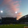 |
| |
| Super Old pic of Portman Road on 14:00 - Jan 29 with 1109 views | Churchman |
| Super Old pic of Portman Road on 11:31 - Jan 29 by Vic |
So Churchmans was named after your dad then really! |
And the RAF. He played for them as well! Interesting pic of the Portman (Cobbold) stand being built in 1971.
Cattle market in the foreground and an all round general view of PR at the time.
https://www.ipswichstar.co.uk/ [Post edited 29 Jan 14:20]
|  | | |
| Super Old pic of Portman Road on 19:31 - Jan 29 with 1000 views | WeWereZombies |
| Super Old pic of Portman Road on 12:25 - Jan 29 by Dubtractor |
Assume that would explain the old John Player sports ground in Ipswich? |
I thought John Player and Sons of Nottingham, had acquired Churchmans but AI tells me different:
'John Player & Sons did not directly buy Churchmans tobacco. Instead, both companies were founding members of the Imperial Tobacco Company in 1901. Later, in 1972, the Churchmans cigar business was integrated with John Player & Sons as part of the broader Imperial Tobacco group.
1901: John Player & Sons, Churchmans, and others formed Imperial Tobacco.
1972: Churchmans cigar business was integrated with John Player & Sons.
1992: Production for both was moved to Bristol, and the Churchmans factory closed. ' |  |
| |
| Super Old pic of Portman Road on 22:38 - Jan 29 with 952 views | MisterBlue |
| Super Old pic of Portman Road on 09:27 - Jan 29 by mellowblue |
I remember there being issues with the height of the Sir Alf Stand being South pf the pitch, but not the West Stand. It does not cause any shadows apart from when the sun is very low. |
Yes, Alan only joined the club in the mid 90's, and as you say did have issues when the North stand and Churhmans were made bigger, that's why the South stand has a more opaque roof towards the front. |  | | |
| Super Old pic of Portman Road on 09:47 - Jan 30 with 862 views | DJR |
| Super Old pic of Portman Road on 10:31 - Jan 29 by Churchman |
Attached is a map of Ipswich from 1867.
https://maps.nls.uk/view/24595
The cattle market is there. The street patterns are the same, more or less. Noticeably Portman Road is Portmans Road.
The area where the council buildings are off Russell Road were being used but basically west of the cattle market there is nothing much. The area now occupied by the football ground is identifiable. |
For anyone interested, here's a site with links to earlier maps of Ipswich.
https://ipswich-lettering.co.u
The following from 1778 and 1780 pre-date the Victorian era, and show that what is now Portman Road may well have been part of the flood plain.
https://ipswich-lettering.co.u
https://ipswich-lettering.co.u
For bearing, St Matthew's Church is in the top left hand corner.
I haven't been able to find any full-scale maps between those maps and the map of 1867. [Post edited 30 Jan 9:48]
|  | | |
| Super Old pic of Portman Road on 09:50 - Jan 30 with 862 views | Superfrans |
Impressive. One of the very earliest drone shots… |  |
| |
Login to get fewer ads
| Super Old pic of Portman Road on 10:23 - Jan 30 with 840 views | WeWereZombies |
| Super Old pic of Portman Road on 09:50 - Jan 30 by Superfrans |
Impressive. One of the very earliest drone shots… |
They're just hot air balloons without the romance, aren't they ? | |
| |
| Super Old pic of Portman Road on 12:03 - Jan 30 with 802 views | The_Major |
| Super Old pic of Portman Road on 12:49 - Jan 29 by NthQldITFC |
Don't tell the budgies, they'll have a field day! Binmen playing football at the rubbish tip.
Hopefully that ground is compacted enough (or will be) for the new 20,000 seater Sir Kieran McKenna Stand which will soon be standing upon it. |
Think I'd have to dust off my Men Who Made The Town, but I think the waste is still actually there beneath Portman Road. The pitch etc was just built on top.
In fact, I seem to recall there being an issue with it when they put the foundations in for the Pioneer - suspect they might have also had a problem when they put the undersoil heating in.
The town rubbish tip would have then been moved to Landseer Road, before that was grassed over to become Landseer Park. Not sure where it went after that - got a feeling it was at the present day site out at Foxhall near the roundabout with the A12? |  | | |
| Super Old pic of Portman Road on 17:03 - Jan 30 with 736 views | Churchman |
| Super Old pic of Portman Road on 12:03 - Jan 30 by The_Major |
Think I'd have to dust off my Men Who Made The Town, but I think the waste is still actually there beneath Portman Road. The pitch etc was just built on top.
In fact, I seem to recall there being an issue with it when they put the foundations in for the Pioneer - suspect they might have also had a problem when they put the undersoil heating in.
The town rubbish tip would have then been moved to Landseer Road, before that was grassed over to become Landseer Park. Not sure where it went after that - got a feeling it was at the present day site out at Foxhall near the roundabout with the A12? |
From ‘The Men Who Made The Town’ (edited down a bit)
‘Portman Road took its name from the ancient office of Portmen. Portmen later became Aldermen. The area around the present ground was formerly a marsh and the ancient Portmen were each bequeathed seven acres of grassland by the Borough to support their horses.’
In the book is an 1888 plan. Football, cricket and for a spell rugby were played on what is now the practice pitch.
‘Where the current pitch is situated was formerly a piece of rough ground containing trees. Trees also lined Portman Road itself’. Under the map it is described as rough wasteland. Looking at the proximity of buildings, I have my doubts that it was used as a rubbish dump, though it might have been in the dim and distant past - happy to be corrected. My opinion is purely based on how the map looks.
I noticed that the roof of the Chicken Run was blown into the roadway and onto the trees and tramlines in a storm on 6 Nov 1911. My guess is that is when the trees were finally removed from Portman Road.
While the base of the stand was un damaged, the roof to the Chicken Run was replaced at a cost of £60. I wonder how much it’ll cost to replace the roof of the West Stand, if that ever happens?
The current Cobbold (Portman) stand initially cost £180,000 and was built in 102 days. The extensions were added by 1975 and the total cost was £500,000. It looks very smart in the picture of it in its full, original form. | | | |
| Super Old pic of Portman Road on 19:14 - Jan 30 with 707 views | mellowblue |
| Super Old pic of Portman Road on 17:03 - Jan 30 by Churchman |
From ‘The Men Who Made The Town’ (edited down a bit)
‘Portman Road took its name from the ancient office of Portmen. Portmen later became Aldermen. The area around the present ground was formerly a marsh and the ancient Portmen were each bequeathed seven acres of grassland by the Borough to support their horses.’
In the book is an 1888 plan. Football, cricket and for a spell rugby were played on what is now the practice pitch.
‘Where the current pitch is situated was formerly a piece of rough ground containing trees. Trees also lined Portman Road itself’. Under the map it is described as rough wasteland. Looking at the proximity of buildings, I have my doubts that it was used as a rubbish dump, though it might have been in the dim and distant past - happy to be corrected. My opinion is purely based on how the map looks.
I noticed that the roof of the Chicken Run was blown into the roadway and onto the trees and tramlines in a storm on 6 Nov 1911. My guess is that is when the trees were finally removed from Portman Road.
While the base of the stand was un damaged, the roof to the Chicken Run was replaced at a cost of £60. I wonder how much it’ll cost to replace the roof of the West Stand, if that ever happens?
The current Cobbold (Portman) stand initially cost £180,000 and was built in 102 days. The extensions were added by 1975 and the total cost was £500,000. It looks very smart in the picture of it in its full, original form. |
I was about 9 when the Cobbold stand was built. It looked huge to me at the time, probably as it was only 2/3rds of the full width it is now and there was nothing to the left and right of it, which made it looked even taller. It was almost as if aliens had dumped this great big stand by the side of the pitch. At age 9 in 1970/1 I had no idea that it was going to be built. Was a big suprise at the time. |  | | |
| Super Old pic of Portman Road on 02:02 - Jan 31 with 676 views | flykickingbybgunn |
Has anybody on here not noticed that at PR today the end stands are off set to the pitch ? This being because the pitch was wider at one point. |  | | |
| Super Old pic of Portman Road on 02:12 - Jan 31 with 669 views | The_Major |
| Super Old pic of Portman Road on 17:03 - Jan 30 by Churchman |
From ‘The Men Who Made The Town’ (edited down a bit)
‘Portman Road took its name from the ancient office of Portmen. Portmen later became Aldermen. The area around the present ground was formerly a marsh and the ancient Portmen were each bequeathed seven acres of grassland by the Borough to support their horses.’
In the book is an 1888 plan. Football, cricket and for a spell rugby were played on what is now the practice pitch.
‘Where the current pitch is situated was formerly a piece of rough ground containing trees. Trees also lined Portman Road itself’. Under the map it is described as rough wasteland. Looking at the proximity of buildings, I have my doubts that it was used as a rubbish dump, though it might have been in the dim and distant past - happy to be corrected. My opinion is purely based on how the map looks.
I noticed that the roof of the Chicken Run was blown into the roadway and onto the trees and tramlines in a storm on 6 Nov 1911. My guess is that is when the trees were finally removed from Portman Road.
While the base of the stand was un damaged, the roof to the Chicken Run was replaced at a cost of £60. I wonder how much it’ll cost to replace the roof of the West Stand, if that ever happens?
The current Cobbold (Portman) stand initially cost £180,000 and was built in 102 days. The extensions were added by 1975 and the total cost was £500,000. It looks very smart in the picture of it in its full, original form. |
See where you're coming from regarding the housing proximity - would guess those on Alderman Road for example are Victorian?
I think the Landseer dump was there until the sixties, certainly my mother can remember it there when she went to the school in Robeck Road. I mean, I know there would have been housing relatively near tha site even then (Rivers Estate, Hayman/Bonnington/Hogarth Roads) but nowhere near the proximity that Alderman Road is to the stadium site. | | | |
| Super Old pic of Portman Road on 08:11 - Jan 31 with 620 views | flykickingbybgunn |
| Super Old pic of Portman Road on 10:31 - Jan 29 by Churchman |
Attached is a map of Ipswich from 1867.
https://maps.nls.uk/view/24595
The cattle market is there. The street patterns are the same, more or less. Noticeably Portman Road is Portmans Road.
The area where the council buildings are off Russell Road were being used but basically west of the cattle market there is nothing much. The area now occupied by the football ground is identifiable. |
The route of the river Gipping is interesting as it then runs to the north of the cattle market almost to the Orwell. And I notice there were two gaols. One for the county and one for the borough. | | | |
| Super Old pic of Portman Road on 08:15 - Jan 31 with 616 views | Churchman |
| Super Old pic of Portman Road on 02:12 - Jan 31 by The_Major |
See where you're coming from regarding the housing proximity - would guess those on Alderman Road for example are Victorian?
I think the Landseer dump was there until the sixties, certainly my mother can remember it there when she went to the school in Robeck Road. I mean, I know there would have been housing relatively near tha site even then (Rivers Estate, Hayman/Bonnington/Hogarth Roads) but nowhere near the proximity that Alderman Road is to the stadium site. |
The houses in Alderman Road seem to have been added at various times but the closest to North Stand are certainly late Victorian. The large one nearest to North Stand on the corner appears on the 1880s map in the book, though that may have been replaced by the current one by the end of the 19c.
According to the Ken Rice Ipswich book from about 1974, the Portman Road ground was considered the best for miles around. Colchester’s was so bad being covered in glass etc, Ipswich refused to play on it. I guess it’s an interesting insight into how open spaces were used 150 years ago.
Also in that book is a team picture from the very early 1900s, before the Chicken Run taken in front of the old cricket Pavilion. There’s an awful lot of buildings in the gloomy background. | | | |
| Super Old pic of Portman Road on 08:32 - Jan 31 with 590 views | peterleeblue |
Fascinating - thanks for sharing. [Post edited 31 Jan 8:40]
|  | | |
| Super Old pic of Portman Road on 17:46 - Feb 1 with 449 views | Churchman |
Came across another picture of Portman Rd taken in 1902 from the chimney that was put up at that time where the bus garage is now.
It shows the pitch not on the car park side but on the Portman Walk side in from of the pavilion building put up in 1888. It is running east to west.
More interesting in the background is the wasteland that occupied much of the ground the stadium sits on now. It was fenced off but certainly at that time was not a rubbish tip. Plenty of trees but basically the land at the time was being used for storage, probably by the businesses opposite. There are stacks of timber, other stuff piled up in the area.
There must be more pics out there! | | | |
| Super Old pic of Portman Road on 18:09 - Feb 1 with 436 views | DJR |
| Super Old pic of Portman Road on 21:42 - Jan 28 by DJR |
Fascinating also to see all the long disappeared houses. And at the top middle in white, I think you can make out the Black Horse, with the church (St. Peter's?) near to it.
Here's a link to a 1927 map which you can zoom in on to see the ground and stand.
https://maps.nls.uk/view/11450 [Post edited 28 Jan 21:52]
|
Having looked at the aerial photo again, and at maps from 1927 to 1973, it seems that the houses on and just to the north of Great Gipping Street, just to the north of the old GRE building, have survived.
That's the route I often take to the ground from the Greyhound, crossing Civic Drive from what used to be the police station. [Post edited 1 Feb 21:00]
| | | |
| Super Old pic of Portman Road on 20:39 - Feb 1 with 408 views | The_Major |
| Super Old pic of Portman Road on 08:11 - Jan 31 by flykickingbybgunn |
The route of the river Gipping is interesting as it then runs to the north of the cattle market almost to the Orwell. And I notice there were two gaols. One for the county and one for the borough. |
That's the Alderman Canal today. Stops just short of Alderman Road, and then goes underground, beneath Great Gipping Street (Hence the name) Civic Drive, Greyfriars, and Cardinal Park before coming out near Stoke Bridge. There's a bit of a bump in Wolsey Street where it goes over the course of the river.
There's apparently also the Mill River, which comes from the springs that give Spring Road it's name - there's a dip on Foxhall Road just past the Kemball Street junction, near to where the old Bull Motors and Celestion factories were, and then it goes uphill again towards Parliament Road. That's the small valley for the Mill River which flows underneath - it then goes under the St Clement's golf course, EACH, and St Augustines Church, and surfaces somewhere near Foxhall Stadium before heading off to the Deben.
What somebody else said upthread about the street patterns had a good point as well – yes, there’s been changes over the last 100 years, but not to the degree of say Plymouth or Coventry, both of which got absolutely flattened during WW2. Of course, there were plans to change it big time.
Those of us over 40 will probably remember the Civic Drive dual carriageway continuing along Franciscan Way, over what is now Cromwell Square, and coming to a grinding halt at St Nicholas Street – the plan was to have an entire ring of dual carriageway roads around the town centre – you can see the plans on the Ipswich Lettering site – from St Nicholas Street, it would have continued east, a roundabout with Silent Street near the Old Cattle Market, another one with Fore Street, then north via Bond Street to a huge one on Majors Corner.
Then westbound traffic would have gone via Old Foundry Road and Tower Ramparts, whilst eastbound would have used Crown and St Margarets Street – another roundabout at the top of Lloyds Avenue, and then it links back up to St Matthews Street.
People had a fit when they heard about this – it would have wiped out a lot of centuries old buildings in Silent and Foundation Streets, not to mention probably either the Halberd or Pykenham’s Gateway having to go to let the vastly widened Old Foundry Road get past Northgate Street.
So, it was dropped, and Civic Drive was really only the main newly built route done. And even that was over the route of old streets – there’s that small terrace of three or four houses on Civic Drive just before Curve by the Greyfriars junction – by my reckoning, given the age of the houses, that’s all that’s left of Tanners Lane, which ran along the same route parallel to Curriers Lane.
Until the Stoke Bridge roundabouts were put in, and Greyfriars/Franciscan Way was all linked up, more often than not, if you were trying to get to Portman Road, the station, Chantry, or even head out on London Road, you’d go across town not via the Docks, but via Rope Walk/Tacket Street/Falcon Street/Friars Street/Princes Street/Ranelagh Road – it was just so much quicker – even today most of that route is designated as a B road, but obviously you can’t go end to end now.
There was a warren of streets in the area of what was called The Mount. The main road in from Colchester carried on up the old bit of London Road, past Burlington church, and met Norwich Road at Barrack Corner. Handford Road used to flow into Elm Street – and given that steep hill just before the roundabout now on Handford Road, makes sense it’d be called the Mount.
Friars Bridge Road, now only a short stump off Princes Street originally went from Greyfriars across the Cattle Market to come out opposite the junction with Portmans Walk (as was) – the entrance to the car park follows the same route today.
One thing I did find out in recent years was that Ipswich was supposed to have the Peterborough treatment in the sixties – the Government wanted to turn it into a new town, and have dual carriageways everywhere – with the A12 and A14 (then A45) turned into motorways, and a couple of interesting new roads built – firstly a relief road for Norwich Road, going via Lovetofts Drive, across the Bramford Lane recreation ground, then via what eventually has turned out to be Europa Way, Boss Hall, and a new road along the side of the river to come out on Yarmouth Road. That makes sense, having lived for many years back in the day near that final stretch of Bramford Road just before the bypass, there were constant rumours of a road being knocked through to Sproughton Road, even back in the eighties.
Then there was the idea to take the traffic off Wherstead Road, and have the main road out towards Manningtree as Birkfield Drive. Again, that makes sense when you think about it – considering it’s basically an estate access road, it does seem ridiculously overbuilt – dead straight, fairly wide, and it also explains that hairpin bend…. | | | |
| Super Old pic of Portman Road on 21:19 - Feb 1 with 378 views | Dubtractor |
| Super Old pic of Portman Road on 20:39 - Feb 1 by The_Major |
That's the Alderman Canal today. Stops just short of Alderman Road, and then goes underground, beneath Great Gipping Street (Hence the name) Civic Drive, Greyfriars, and Cardinal Park before coming out near Stoke Bridge. There's a bit of a bump in Wolsey Street where it goes over the course of the river.
There's apparently also the Mill River, which comes from the springs that give Spring Road it's name - there's a dip on Foxhall Road just past the Kemball Street junction, near to where the old Bull Motors and Celestion factories were, and then it goes uphill again towards Parliament Road. That's the small valley for the Mill River which flows underneath - it then goes under the St Clement's golf course, EACH, and St Augustines Church, and surfaces somewhere near Foxhall Stadium before heading off to the Deben.
What somebody else said upthread about the street patterns had a good point as well – yes, there’s been changes over the last 100 years, but not to the degree of say Plymouth or Coventry, both of which got absolutely flattened during WW2. Of course, there were plans to change it big time.
Those of us over 40 will probably remember the Civic Drive dual carriageway continuing along Franciscan Way, over what is now Cromwell Square, and coming to a grinding halt at St Nicholas Street – the plan was to have an entire ring of dual carriageway roads around the town centre – you can see the plans on the Ipswich Lettering site – from St Nicholas Street, it would have continued east, a roundabout with Silent Street near the Old Cattle Market, another one with Fore Street, then north via Bond Street to a huge one on Majors Corner.
Then westbound traffic would have gone via Old Foundry Road and Tower Ramparts, whilst eastbound would have used Crown and St Margarets Street – another roundabout at the top of Lloyds Avenue, and then it links back up to St Matthews Street.
People had a fit when they heard about this – it would have wiped out a lot of centuries old buildings in Silent and Foundation Streets, not to mention probably either the Halberd or Pykenham’s Gateway having to go to let the vastly widened Old Foundry Road get past Northgate Street.
So, it was dropped, and Civic Drive was really only the main newly built route done. And even that was over the route of old streets – there’s that small terrace of three or four houses on Civic Drive just before Curve by the Greyfriars junction – by my reckoning, given the age of the houses, that’s all that’s left of Tanners Lane, which ran along the same route parallel to Curriers Lane.
Until the Stoke Bridge roundabouts were put in, and Greyfriars/Franciscan Way was all linked up, more often than not, if you were trying to get to Portman Road, the station, Chantry, or even head out on London Road, you’d go across town not via the Docks, but via Rope Walk/Tacket Street/Falcon Street/Friars Street/Princes Street/Ranelagh Road – it was just so much quicker – even today most of that route is designated as a B road, but obviously you can’t go end to end now.
There was a warren of streets in the area of what was called The Mount. The main road in from Colchester carried on up the old bit of London Road, past Burlington church, and met Norwich Road at Barrack Corner. Handford Road used to flow into Elm Street – and given that steep hill just before the roundabout now on Handford Road, makes sense it’d be called the Mount.
Friars Bridge Road, now only a short stump off Princes Street originally went from Greyfriars across the Cattle Market to come out opposite the junction with Portmans Walk (as was) – the entrance to the car park follows the same route today.
One thing I did find out in recent years was that Ipswich was supposed to have the Peterborough treatment in the sixties – the Government wanted to turn it into a new town, and have dual carriageways everywhere – with the A12 and A14 (then A45) turned into motorways, and a couple of interesting new roads built – firstly a relief road for Norwich Road, going via Lovetofts Drive, across the Bramford Lane recreation ground, then via what eventually has turned out to be Europa Way, Boss Hall, and a new road along the side of the river to come out on Yarmouth Road. That makes sense, having lived for many years back in the day near that final stretch of Bramford Road just before the bypass, there were constant rumours of a road being knocked through to Sproughton Road, even back in the eighties.
Then there was the idea to take the traffic off Wherstead Road, and have the main road out towards Manningtree as Birkfield Drive. Again, that makes sense when you think about it – considering it’s basically an estate access road, it does seem ridiculously overbuilt – dead straight, fairly wide, and it also explains that hairpin bend…. |
I read loads of stuff like this via the Ipswich Society. The planned dual carriageway through Ipswich was mad, and would have destroyed the middle of town.
I like that the car park behind the Willis building was originally part of that road, having knocked a row of houses down, but now survives as a long thin car park. | |
| |
| Super Old pic of Portman Road on 21:24 - Feb 1 with 356 views | The_Major |
| Super Old pic of Portman Road on 21:19 - Feb 1 by Dubtractor |
I read loads of stuff like this via the Ipswich Society. The planned dual carriageway through Ipswich was mad, and would have destroyed the middle of town.
I like that the car park behind the Willis building was originally part of that road, having knocked a row of houses down, but now survives as a long thin car park. |
That used to be Cromwell STREET before they built the dual carriageway Franciscan Way. Like you say, there was another terrace row on the opposite side to the one that remains. | | | |
| Super Old pic of Portman Road on 08:40 - Feb 2 with 270 views | DJR |
| Super Old pic of Portman Road on 20:39 - Feb 1 by The_Major |
That's the Alderman Canal today. Stops just short of Alderman Road, and then goes underground, beneath Great Gipping Street (Hence the name) Civic Drive, Greyfriars, and Cardinal Park before coming out near Stoke Bridge. There's a bit of a bump in Wolsey Street where it goes over the course of the river.
There's apparently also the Mill River, which comes from the springs that give Spring Road it's name - there's a dip on Foxhall Road just past the Kemball Street junction, near to where the old Bull Motors and Celestion factories were, and then it goes uphill again towards Parliament Road. That's the small valley for the Mill River which flows underneath - it then goes under the St Clement's golf course, EACH, and St Augustines Church, and surfaces somewhere near Foxhall Stadium before heading off to the Deben.
What somebody else said upthread about the street patterns had a good point as well – yes, there’s been changes over the last 100 years, but not to the degree of say Plymouth or Coventry, both of which got absolutely flattened during WW2. Of course, there were plans to change it big time.
Those of us over 40 will probably remember the Civic Drive dual carriageway continuing along Franciscan Way, over what is now Cromwell Square, and coming to a grinding halt at St Nicholas Street – the plan was to have an entire ring of dual carriageway roads around the town centre – you can see the plans on the Ipswich Lettering site – from St Nicholas Street, it would have continued east, a roundabout with Silent Street near the Old Cattle Market, another one with Fore Street, then north via Bond Street to a huge one on Majors Corner.
Then westbound traffic would have gone via Old Foundry Road and Tower Ramparts, whilst eastbound would have used Crown and St Margarets Street – another roundabout at the top of Lloyds Avenue, and then it links back up to St Matthews Street.
People had a fit when they heard about this – it would have wiped out a lot of centuries old buildings in Silent and Foundation Streets, not to mention probably either the Halberd or Pykenham’s Gateway having to go to let the vastly widened Old Foundry Road get past Northgate Street.
So, it was dropped, and Civic Drive was really only the main newly built route done. And even that was over the route of old streets – there’s that small terrace of three or four houses on Civic Drive just before Curve by the Greyfriars junction – by my reckoning, given the age of the houses, that’s all that’s left of Tanners Lane, which ran along the same route parallel to Curriers Lane.
Until the Stoke Bridge roundabouts were put in, and Greyfriars/Franciscan Way was all linked up, more often than not, if you were trying to get to Portman Road, the station, Chantry, or even head out on London Road, you’d go across town not via the Docks, but via Rope Walk/Tacket Street/Falcon Street/Friars Street/Princes Street/Ranelagh Road – it was just so much quicker – even today most of that route is designated as a B road, but obviously you can’t go end to end now.
There was a warren of streets in the area of what was called The Mount. The main road in from Colchester carried on up the old bit of London Road, past Burlington church, and met Norwich Road at Barrack Corner. Handford Road used to flow into Elm Street – and given that steep hill just before the roundabout now on Handford Road, makes sense it’d be called the Mount.
Friars Bridge Road, now only a short stump off Princes Street originally went from Greyfriars across the Cattle Market to come out opposite the junction with Portmans Walk (as was) – the entrance to the car park follows the same route today.
One thing I did find out in recent years was that Ipswich was supposed to have the Peterborough treatment in the sixties – the Government wanted to turn it into a new town, and have dual carriageways everywhere – with the A12 and A14 (then A45) turned into motorways, and a couple of interesting new roads built – firstly a relief road for Norwich Road, going via Lovetofts Drive, across the Bramford Lane recreation ground, then via what eventually has turned out to be Europa Way, Boss Hall, and a new road along the side of the river to come out on Yarmouth Road. That makes sense, having lived for many years back in the day near that final stretch of Bramford Road just before the bypass, there were constant rumours of a road being knocked through to Sproughton Road, even back in the eighties.
Then there was the idea to take the traffic off Wherstead Road, and have the main road out towards Manningtree as Birkfield Drive. Again, that makes sense when you think about it – considering it’s basically an estate access road, it does seem ridiculously overbuilt – dead straight, fairly wide, and it also explains that hairpin bend…. |
I remember the plans to increase the population that came to nothing.
Here's a link to an Anglia News item from 1965, which includes an aerial view of Ipswich at the time
https://eafa.org.uk/work/?id=1
And here's a link to a report from 1968 suggesting various alternatives as to how the expansion might take place, involving the expansion of Martlesham, Belstead and Bramford.
https://ia601308.us.archive.or
As regards the Ipswich Lettering Society, its website is a fantastic source of information about the buildings and history of Ipswich.
https://ipswich-lettering.co.u
From it, for example, I discovered the existence of an old Jewish cemetery that I knew nothing about.
https://www.ipswich-lettering. [Post edited 2 Feb 8:41]
| | | |
| Super Old pic of Portman Road on 10:21 - Feb 2 with 241 views | NthQldITFC |
| Super Old pic of Portman Road on 08:11 - Jan 31 by flykickingbybgunn |
The route of the river Gipping is interesting as it then runs to the north of the cattle market almost to the Orwell. And I notice there were two gaols. One for the county and one for the borough. |
I noticed that as well. I wonder when it was diverted south? | |
| |
| Super Old pic of Portman Road on 10:33 - Feb 2 with 228 views | ITFC_Forever |
As an ex-employee of Guardian from the mid-90s, I’m also a member of an old GRE employees Facebook page and that has recently had old pictures of the GRE buildings from the air, a number of which include the ground in them as well. |  |
| |
| |
